BEAD Deployments May Need Hundreds of Thousands of Private Easements
BEAD
easements
An analysis of BEAD and property data in 17 states finds that about one in seven BEAD locations cannot reach a public road without crossing land someone else owns. States can ease that by opening existing utility easements to broadband, as Virginia has.
Key Takeaways
- In the 17 states we analyzed, about one in seven BEAD locations cannot reach a public road without crossing land someone else owns. That is 196,427 of the 1.33 million locations in those states, or 14.8%. This indicates that private property access may be relevant to a substantial number of BEAD locations, in addition to the public right-of-way permits an ISP already must secure from state and local governments.
- If the 14.8% rate held across all BEAD locations, that would be about 557,000 locations that cannot reach a road. BEAD funds 3.76 million locations nationwide. We were unable to measure the other states because the necessary data is not publicly available.
- Much of the potential private-property access issue appears to be driven by properties located along private or otherwise non-public roads, rather than isolated parcels behind a single neighboring property. 66.3% of crossing locations front shared lanes, subdivision streets, or other roads that are absent from the public road inventory.
- State rates vary widely. They run from 4.9% in Massachusetts to 33.0% in North Carolina, largely reflecting how each state treats local and subdivision roads.
- This analysis measures the relationship between BEAD location parcels and the public road network and does not use actual infrastructure deployment routes. BEAD deployment routes are not public, so we test whether a location’s parcel can reach a public road without crossing separately owned private property.
NoteFull Report Available
This post summarizes our BEAD Easement Analysis report, which includes state-by-state results, the parcel data sources used, and a detailed methodology.
Overview
Broadband networks are built on a mix of public and private property. Deploying facilities within a public right-of-way typically requires permission from the government entity with jurisdiction over that right-of-way, usually in the form of a permit, to place equipment there, which is its own substantial burden. When a deployment requires use of private property and no sufficient existing property right applies, an ISP generally must obtain permission from the private property owner, often through an easement or other agreement.
Private easements are a different kind of problem from public right-of-way permits. Public right-of-way access generally involves an established authority, process, and fee schedule. Private easements involve property owners, who may be unreachable, may include multiple co-owners, may be an estate in probate, or may simply be unwilling to discuss an easement.
Deployment routes of BEAD projects are not public, and states’ Final Proposal data show only the locations in a funded project. As a result, it is impossible to perform an engineering-level analysis of the full scale of each subgrantee’s potential private easement need. Instead, in the states where parcel data allows it, we attempt to identify a baseline indicator of potential access challenges by measuring what proportion of BEAD locations sit on parcels that cannot reach a public road without crossing separately owned private property. We matched 1.33 million BEAD locations in 17 states to the parcels they sit on, using publicly available statewide parcel data (i.e., available at no cost and in a readily usable format), and tested whether each parcel can reach a public road without crossing a parcel under different ownership.
Actual broadband routes may cross multiple private parcels or follow existing utility corridors rather than connect each location to a public road. Even without route data, the analysis helps identify the scale of potential private-property access issues and where existing easements or other property rights may need to be evaluated. These 17 states are not a random sample of the country, and the rate should not be read as a national figure.
What This Looks Like on the Ground
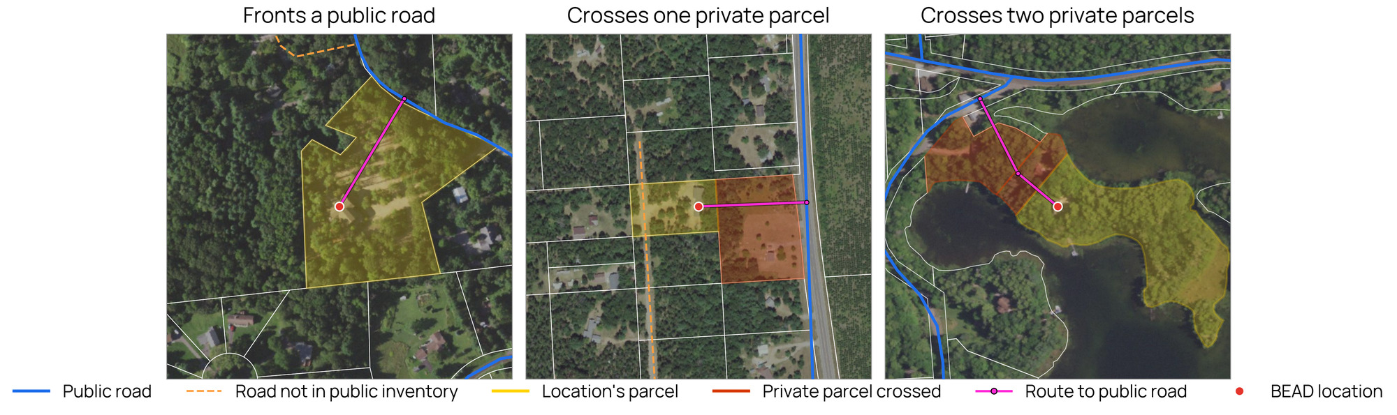
The three cases above are the three outcomes we count. A location whose parcel touches a public road is much more likely to be servable without a private easement. A location that can only reach a road across one or more parcels under different ownership is much more likely to require a private easement. These classifications do not establish whether an easement is actually required. A deployment may follow another route, including a route along an existing utility corridor, and may require property rights even for a location whose parcel fronts a public road. However, even where no new easement ultimately is required, significant parcel-level research may be needed to identify existing easements or other property rights, determine their scope, and evaluate whether they can support broadband deployment. That diligence itself can add time, cost, and complexity to a project.
How Many Locations Are Affected
| Access to a public road | Locations | Share |
|---|---|---|
| Fronts a public road | 1,099,676 | 82.9% |
| Crosses public land only | 23,010 | 1.7% |
| Crosses one private parcel | 188,478 | 14.2% |
| Crosses two or more private parcels | 7,949 | 0.6% |
| No land route, or no matched parcel | 6,994 | 0.5% |
| All locations | 1,326,107 | 100.0% |
82.9% of locations front a public road directly. A further 1.7% reach a public road only across government-owned land, which we do not count as a private-property crossing. The remaining 196,427 locations, 14.8% of the total, must cross land in private hands.
Because the analysis measures parcel-to-road relationships rather than actual network routes, these figures identify potential private-property access issues rather than the number of property rights an ISP ultimately will need.
Of those, 66.3% sit on a road that is not in the public road inventory. These are the shared lanes and subdivision streets that look like ordinary roads on a map but are not identified as public roads in the datasets used for this analysis. The rest sit behind parcels that themselves front a public road.
Where the Burden Falls
The spread is wide. North Carolina is the highest state we analyzed at 33.0%, roughly 7 times the rate in Massachusetts. Much of that difference is due to differences between states’ handling of local and subdivision roads. In the states with the highest rates, most crossing locations are not behind a back lot at all. They sit on streets that are not included in the public road inventory: 68.1% of North Carolina’s crossing locations and 77.7% of Florida’s, against 20.6% in Massachusetts and 36.2% in Arkansas. Where a state’s department of transportation is responsible for most public roads, and subdivision streets stay private unless the state accepts them into its system, more of the local network stays in private hands and more locations have no public road to connect to.
Why This Matters
Among the array of permissions that ISPs need to obtain before they can deploy a broadband network, private easements are among the least discussed. Indeed, in this context, most NTIA and state-level BEAD guidance focuses primarily on facilitating access to public rights-of-way, likely because a comprehensive body of law, policy, and regulation already exists to guide these processes (though, as we have argued many times in the past, these processes are in desperate need of a revamp).
Given this dearth of guidance, private easements could become a major impediment to timely and cost-effective BEAD builds. If an ISP cannot locate an owner of a parcel or secure permission to access the owner’s land to support a build, then a project may be delayed or require a new design (sometimes to remove locations to be served), adding time and money to projects that are already operating on tight timelines and budgets, and defeating the BEAD mission to bring broadband service to all unserved locations. Notably, two thirds of the identified private property crossings are not associated with isolated back lots. Most are homes and businesses along established shared lanes and subdivision streets that are not identified as public roads. Many are presumably already served by electric infrastructure, suggesting that electric utilities may hold easements or other access rights along existing corridors that could provide a path for broadband deployment.
What can be done to address these issues? The most straightforward path forward is to encourage states to pass laws that would allow ISPs to leverage existing private easements already held by electric utilities.
Over the last century, utilities amassed thousands of private easements as they extended their networks throughout the country. Over time, states developed laws and policies to govern these agreements and enshrine protections for the private property owner. Nowadays, state property and recording laws, together with the terms of the underlying instruments, govern the creation, recording, modification and transfer of easement rights.
In the recent past, about half the states have passed laws addressing the use of existing utility easements to facilitate broadband deployment. Our review of all 50 states, current as of November 2026, puts the count at 25. The reach and language of these laws differ, though. Virginia, for example, has adopted a relatively broad law addressing the use of certain utility easements for broadband expansion. Va. Code § 55.1-306.1 states, in relevant part:
“Absent any express prohibition on the installation and operation of broadband or other communications services in an easement that is contained in a deed or other instrument by which the easement was granted, the installation and operation of broadband or other communications services within any easement shall be deemed, as a matter of law, to be a permitted use within the scope of every easement for the location and use of electric and communications facilities.”
The law also enshrines the landowner’s property rights and ability to challenge certain easements.
This approach, though, is evident in only eight states. The more prevalent approach among those states that have addressed the issue has been to allow only electric cooperatives to use their existing easements to support fiber deployment. That is the case in 13 states.
The other half of states do not appear to have addressed this issue at all.
By location rather than by state, about 37% of the 3.76 million BEAD-funded locations nationwide sit in states where an ISP can use an existing utility easement, about 22% in states where only the utility or an affiliate can, and about 40% in states that have not opened the easements to broadband. The 17 states we measured span every one of these categories, and the states with the highest crossing rates are spread across them.
With most state legislative sessions set to begin in early 2027, legislators in the states that do not permit appropriate use of existing utility easements for broadband deployment, or have not extended that use to all ISPs, should consider doing so. Model legislation should preserve property owners’ ability to recover compensation for proven physical or monetary harm, while generally providing that disputes over such use do not halt or delay broadband deployment where monetary relief provides an adequate remedy.
Virginia’s experience also suggests that broader easement-use legislation need not necessarily result in widespread litigation or deployment delays. An early legal challenge involving the Virginia law was ultimately dismissed in federal court, and predictions that additional lawsuits might bog down broadband deployment do not appear to have materialized.
If state legislatures fail to act and BEAD projects are negatively impacted, NTIA could help state broadband offices and ISPs in several ways. First, the agency could use the additional BEAD funding round to encourage and incentivize greater coordination between states and ISPs on project revisions to address unforeseen property access challenges, identify workable alternatives, and minimize deployment delays. This could also establish a model for future deployment efforts. Second, NTIA could allow available non-deployment funds to be used to offset any material, unanticipated increases in project costs, including those resulting from additional legal, engineering, and construction expenses.
Third, NTIA could direct available BEAD resources toward modernizing the records this work depends on. County property records often are not digitized, while utility easement and infrastructure records are frequently outdated or incomplete, which complicates every step above. To the extent non-deployment funds remain once the supplemental round is awarded, they could help close those gaps and speed project planning and deployment.
Beyond these near-term federal and programmatic steps, state-level policy reform will be important to addressing the underlying challenges. As with permitting, poles and utility locates, the issue of private easements in the BEAD context highlights yet another area ripe for modernization by state governments. For too long, the processes governing access to property and permission to build critical infrastructure at scale have been allowed to calcify, given the inability of state policymakers to revisit and revise policy frameworks that, in many cases, are decades old and fail to reflect the contours of the modern economy and construction practices. As ever, BEAD presents a unique opportunity to highlight the downsides of continued inaction, which could leave some locations without broadband because projects cannot clear these obstacles, as well as the potential benefits of reform: accelerating deployment and swiftly closing the digital divide.
Methodology
We place each BEAD Final Proposal location using FCC Broadband Fabric coordinates and match it to the parcel it sits on, using publicly available parcel data published by each state. Public roads come from FHWA’s national road inventory, with state road data added where that inventory is incomplete. We then check whether the location’s parcel touches a public road, counting adjacent parcels held by the same owner as part of it. If it does not, we count the fewest separately owned private parcels between the location parcel and a public road under the modeled connection. Government-owned land along the way does not count. The analysis does not count the location parcel itself or model actual broadband routes, which may follow existing utility corridors across multiple private parcels. It therefore measures potential private-property access issues, not the number of easements ultimately required.
The 17 states here are those that make statewide parcel data, with owner names, publicly available. The states are analyzed by county, and a given county is included only where most of its locations match a parcel. The share of BEAD locations retained is reported state by state in the full report.
To check the results, we reviewed a random sample of 196 locations against aerial imagery. That sample implies a modeled private-property crossing rate of 14.3% (95% confidence interval 11.4% to 19.9%), consistent with the 14.8% reported here. Two further checks against independent state road data are described in the full report, along with the complete state-by-state results and the parcel sources used.